


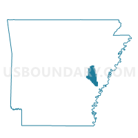
Pine Ridge Voting District, Monroe County, Arkansas
About
Outline

Summary
| Unique Area Identifier | 527388 |
| Name | Pine Ridge Voting District |
| County | Monroe County |
| State | Arkansas |
| Area (square miles) | 19.59 |
| Land Area (square miles) | 19.58 |
| Water Area (square miles) | 0.01 |
| % of Land Area | 99.96 |
| % of Water Area | 0.04 |
| Latitude of the Internal Point | 34.68593960 |
| Longtitude of the Internal Point | -91.18470590 |
Maps


Graphs
Select a template below for downloading or customizing gragh for Pine Ridge Voting District, Monroe County, Arkansas


Neighbors
Neighoring Voting District (by Name) Neighboring Voting District on the Map
- Clarendon Ward 3, Monroe County, AR
- Cypress Ridge Voting District, Monroe County, AR
- Duncan Voting District, Monroe County, AR
- Hindman Voting District, Monroe County, AR
- Keevil Voting District, Monroe County, AR
- Raymond Voting District, Monroe County, AR
Top 10 Neighboring County Subdivision (by Population) Neighboring County Subdivision on the Map
- Cache township, Monroe County, AR (1,851)
- Duncan township, Monroe County, AR (801)
- Cypress Ridge township, Monroe County, AR (339)
- Keevil township, Monroe County, AR (171)
- Pine Ridge township, Monroe County, AR (99)
- Hindman township, Monroe County, AR (91)
- Raymond township, Monroe County, AR (57)